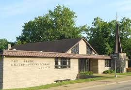
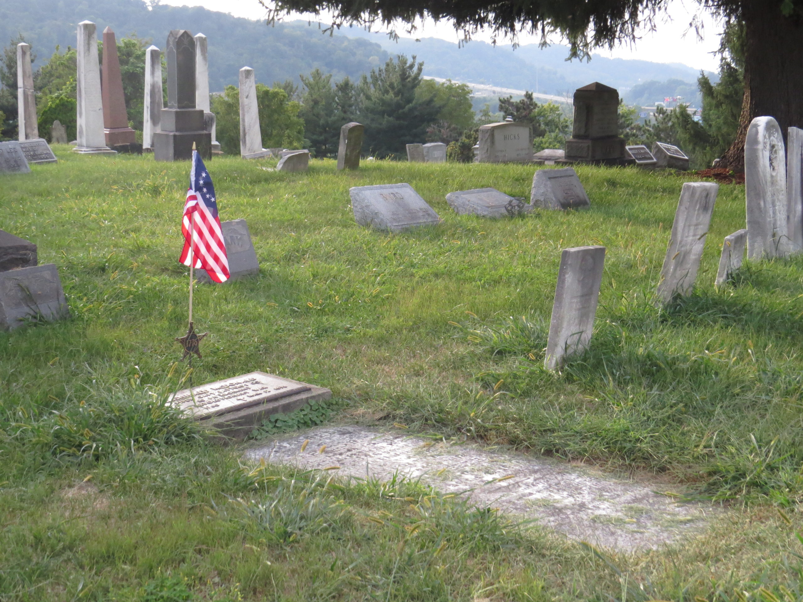
Forks of Wheeling Presbyterian Church (“Old Stone Church”) and Cemetery
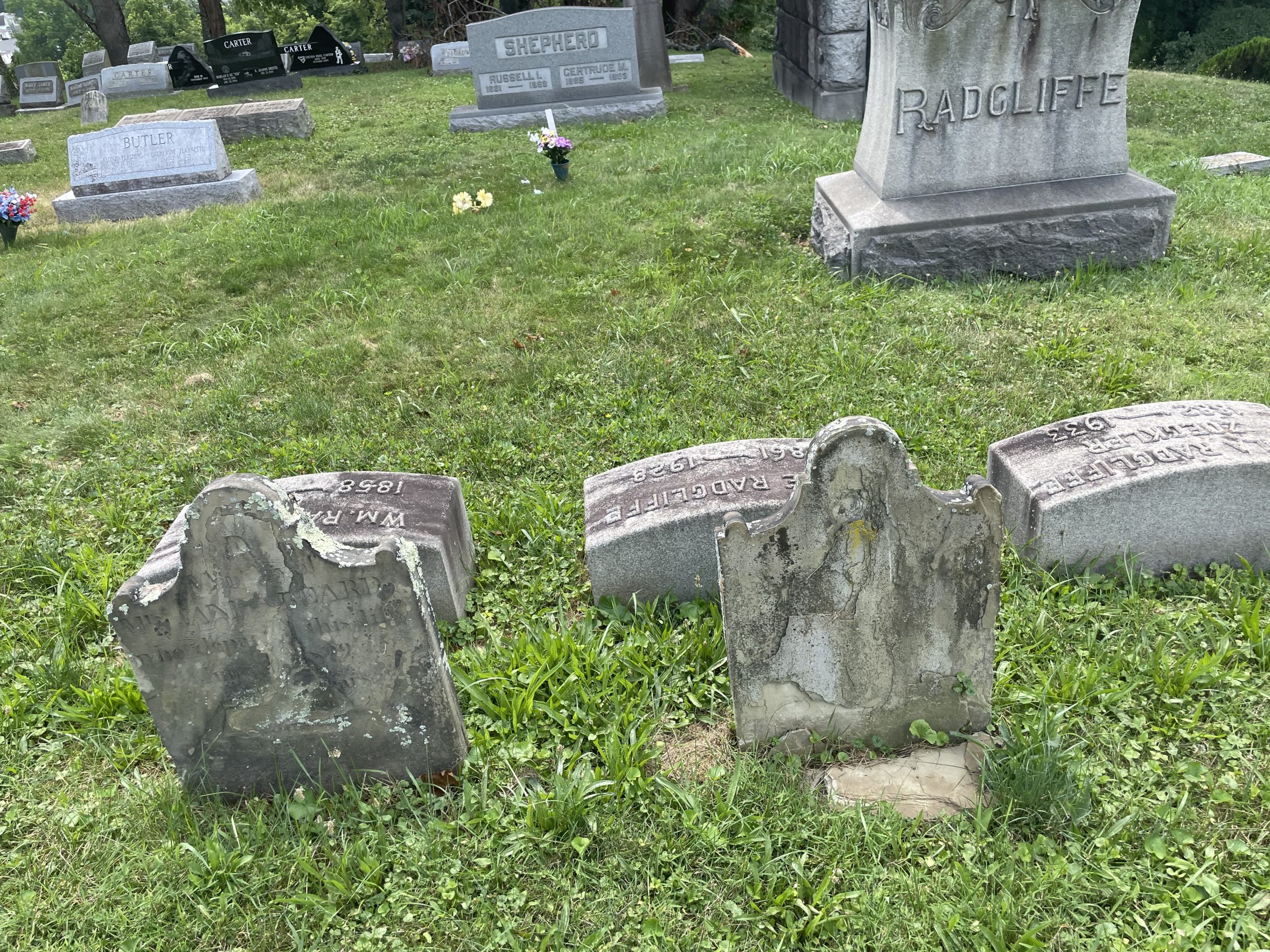
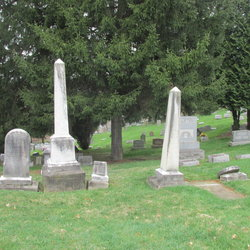
Founded in 1787, Forks of Wheeling Presbyterian Church, known today as Stone United Presbyterian Church, is the oldest Presbyterian church in the area. Not long after Colonel David Shepherd settled here in 1770 he constructed a fort on the site where his son Moses later built Shepherd Hall or Monument Place. Colonel Shepherd whose land grant and settlement occupied most of what is now Elm Grove, gave the fledging Forks of Wheeling congregation permission to meet on his property. He eventually bequeathed this property in 1795 to the Church for worship space, and also for a burying ground. The graves of 15 of the 17 Revolutionary War patriots interred here have been identified. This cemetery remains an active burial place and is owned by the City of Wheeling.
The pioneers first worshipped under an enormous oak tree which later sheltered the church’s first crude, tent-like structure with raised platform, erected in 1790. The oak tree survived until the winter of 1998-99 when it died and was cut down. Its age was estimated at over 300 years. A granite monument marks the location of the original 1807 Stone Church structure and the nearby tree stump is what remains of the old oak tree.


The “Old Stone Church” was built in 1807, “situated on a hill overlooking the beautiful valley where the two forks of the Wheeling Creek unite.” In 1913 the original structure was torn down and replaced with a larger brick church in Gothic revival style, which was dedicated June 14, 1914. This second church building, located on Stone Church Road, was demolished in 1970 for the construction of Interstate 70. A groundbreaking for the present Stone United Presbyterian Church, located at 25 E. Cove Ave. in Elm Grove, was held on May 30, 1971.

Patriots Interred in the Cemetery

GPS Coordinates 40.04212 N, 80.65332 W
John Baird (1749 – Oct. 22, 1832). Served as a Private 2nd Class in Capt. William Leet’s 3rd Battalion, of Washington Co., PA.
Francis Boggs (1758 – July 11, 1825). Born in Chester, PA a son of Ezekiel Boggs (1734 – 1815) and Jane Johnson (1736 – 1808). Served as a Private 5th Class in Capt. Eliazer Williamson’s Co., 3rd Battalion of Washington Co., PA. His father, Ezekiel, signed the Oath of Allegiance in 1777. Francis died in Ohio Co.
Francis married Margaret Caldwell (1764 – 1850), daughter of William Caldwell and Margaret McCune. They had seven children. Their son William (1789 – 1869) is buried nearby. Their daughter Alcy (1769 – 1838) married Abram McColloch (1760 – 1839) who with his three brothers, John, George and Major Samuel of McColloch’s Leap fame, are all recognized patriots.

GPS Coordinates 40.04193 N, 80.65325 W
Richard Carter, Jr. (Sept. 6, 1759 – Oct. 1835) Served in Maryland as an orderly for the sick and wounded and also in the 4th Battalion, Washington County, PA Militia. He married Mary Beall, daughter of Basil Beall. (Marker not found).
Lydia Boggs Shepherd Cruger (Feb. 26, 1766 – Sept. 26, 1867) was among the defenders of Fort Henry during the second siege of Sept. 11, 1782. During the siege she assisted in melting lead for making bullets. She married Moses Shepherd and resided with him at Shepherd Hall (see Moses Shepherd profile). After Moses’ death she remarried newspaper publisher, attorney and NY Congressman Daniel Cruger. Her long life spanned the colonial period and the Civil War.

GPS Coordinates 40.04221, 80.65306 W
A daughter of Captain John Boggs, Lydia was born in Berkeley Co., Virginia, February 26, 1766. Her father Captain Boggs was living at Chartiers Creek, Western Pennsylvania, previous to 1774. In that year he moved with his family to the vicinity of Wheeling. He was the intimate friend and associate of Colonel David Shepherd, and when Fort Henry was besieged by Native warriors, September 1, 1777, Captain Boggs, who was stationed at Catfish Camp, (now Washington, PA) twenty-five miles from Wheeling, came to the rescue with forty men, arriving the following morning and assisted in restoring order, burying the dead and preparing for the further defense of the fort.
Moses Caton Chapline (Oct. 20. 1754 – Feb. 10, 1812). Born in Frederick County, Maryland Moses Caton Chapline was a son of Moses Chapline and Janet Caton. He served with great distinction in the Revolutionary War, as First Lieutenant of the Maryland Battalion of the Flying Camp from June to December 1776, and as First Lieutenant of the 6th Maryland late in 1776 and as Captain in 1777. He fought in the battles of Long Island, Brooklyn Heights, White Plains, the storming of Fort Washington as well as in the battles of Trenton and Princeton. He was wounded at the Battle of Cowpens. His bravery was commended publicly by General George Washington and he was promoted to colonel prior to the war’s end. He served as Clerk of the Court for Ohio County and in 1807 he was Mayor of Wheeling. He married Mary Caldwell, a sister of John Caldwell in 1775; they had 8 children. Among their children was Mary Lovely Chapline who was the wife of Noah Zane. Moses Chapline died on February 10, 1812.

GPS Coordinates 40.04270 N, 80.65344 W
Moses Creighton, listed in various sources as a soldier of the American Revolution. (Marker not found).
Francis Duke (Feb. 11, 1751 – Sept. 1, 1777). Born in Ireland, he emigrated with his family to Berkeley Co., VA where in 1773 he married Sarah Shepherd, a daughter of Col. David Shepherd and Rachel Teague. He removed to Ohio Co. with the Shepherds and was appointed Deputy Commissary, Virginia Militia by his father-in-law and stationed at Beech Bottom Fort. He was killed attempting to enter Fort Henry during the first siege in 1777.

GPS Coordinates 40.04216 N,
80.65295 W
William Faris (1734 – Aug. 1, 1818). Born in County Down, N. Ireland he married Dorothy Johnston in 1758 before they emigrated to America. He enlisted in 1776 in Capt. Bentley’s Company of Col. Marshall’s Regiment, Berkeley Co., VA. (Ref: West Virginians in the American Revolution by Ross B. Johnston.)

GPS Coordinates 40.04208 N,
80.65318 W
Edward Gater (1745 – 1811). Served as a Private 7th Class in the 3rd Battalion of the Washington Co. PA Militia under the command of Capt. Andrew Swearingen.

GPS Coordinates 40.04191 N,
80.65327 W
John Gooding (died Sept. 11, 1818). Served as a Private 8th Class in Capt. Andrew Farley’s 1st Battalion, Washington Co, PA Militia.
GPS Coordinates 40.04195 N, 80.65254 W

William Hervey (c. 1750 – May 22, 1815). Served as a Private in the 2nd Battalion of the Washington Co, PA Militia. Also signed the Oath of Allegiance in Ohio Co., WV. (Marker not found).
Archibald McDonald (1760 – Mar. 12, 1838). He enlisted in April 1777 as a Fifer in the Pennsylvania 10th Regiment of Foot and was discharged August 16, 1783, (Source: Pension Application)
GPS Coordinates 40.04221 N, 80.65295 W


John Milligan (Aug. 1751 – Feb. 5, 1838). Born in County Down, N. Ireland, he came to New Castle, PA at the age of 20. After two years he moved to Berkeley Co., VA where in 1775 he enlisted as a Private in Capt. Hugh Stephenson’s Company of Col. Rawlings Regiment, Virginia Militia and served for a year. In 1776 he served five months in Col. Swope’s Regiment and was at the Battle of Trenton. In 1781 he served two months in Capt. Isaac Evans Company. In 1793 he moved to Ohio Co.
He married Sarah Robinson. Their son Hugh Milligan married Ruth Brown, a daughter of patriot Josias Brown and Hannah Mitchell. Hugh and Ruth’s daughter Elizabeth married Archibald Waddle (Waddell), a son of James Waddle and Elizabeth McDonald who was a daughter of patriot Archibald McDonald and Elizabeth Brownlee. (see his profile above). (Source: Pension Application)

GPS Coordinates 40.04188 N, 80.65253 W
John Mills (Mar. 6, 1752 – Nov. 23, 1833). Served in the 7th, 9th and 13th Regiments of the Virginia Line and was a Lieutenant in Col. John Gibson’s Regiment. On Sept. 13, 1785 he married Ruth Shepherd, a daughter of patriot David Shepherd and Rachel Teague. (Source: Pension Application)

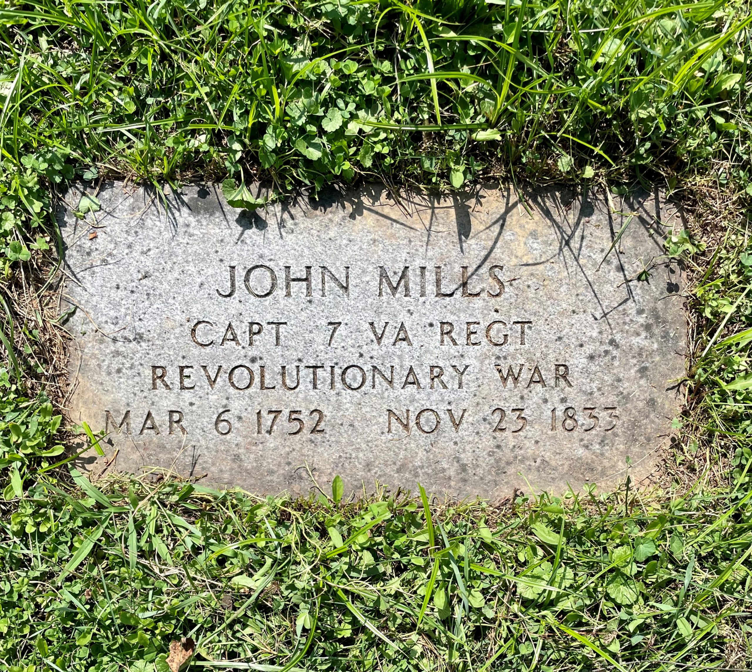
GPS Coordinates 40.04216 N, 80.65318 W
David Shepherd (1734 – Feb. 2, 1795). Served as Colonel of the Ohio Co. Virginia Regiment and was Commander of Fort Henry during the first siege in 1777. (See profile in introductory cemetery description.)

GPS Coordinates 40.04216 N, 80.65311 W
Moses Shepherd (Nov. 1763 – April 9, 1832), a son of David Shepherd and Rachel Teague. Served as a Private in the 5th Company, 3rd Battalion, Washington Co, PA Militia. Was at the second siege of Fort Henry, Sept. 11, 1782. He was married to Lydia Boggs and built Shepherd Hall (or Monument Place) in 1798. He and Lydia were great friends of many prominent politicians of their time, spending their winters in Washington City. Their home was visited by notables including Kentucky Senator Henry Clay, the Marquis de Lafayette and US Presidents William Henry Harrison and James K. Polk. Moses was contracted by the Federal government to build bridges for the National Road including the Monument Place Bridge in Elm Grove, the oldest bridge in WV. Constructed in 1817 it is a relatively rare example of a stone bridge that features the elliptical style of arch. Moses died in the cholera epidemic of 1832 at age 68.
William Shepherd (1758 – Sept. 1, 1777). A son of David Shepherd and Rachel Teague and brother of Moses, was a defender of Fort Henry during the first siege where he was killed.
Archibald Woods (Nov. 14, 1764 – Oct. 26, 1846). Served in the Virginia Militia. In 1788 was sent as a representative of Ohio Co. to the Constitutional Convention in Richmond, VA. Established his homestead “Woodsdale”, which became today’s neighborhood of the same name when his farm was subdivided into building lots in 1891. Also served in the War of 1812 and founded Woodsfield, Monroe Co., OH.

GPS Coordinates 40.04211 N, 80.65311 W